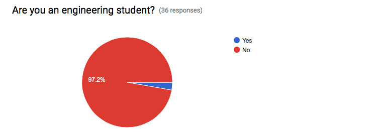
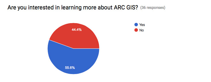
Student Feedback
How did the concept of USER CENTER DESIGN change your making?
-I wanted to make it more interactive and interesting to users, not boring because they are viewing data.
-It helped me become more descriptive
-It helped me visualize what allot of companies do to get their message out clearly to people by making it user friendly.
-The app had to be straight forward for the user and if it was not, instructions had to be given in the simplest way possible to keep the user calm and interested in your app.
-We were able to take our data and turn it into whatever we wanted. Although my group members and I all had the same data, all of our story maps looked different because we were able to customize our maps and the way we presented our data.
-It made me think of myself as an end user. I constantly asked myself... if I was looking at this for the first time would I understand it.
What sort of problems did you encounter and how did you solve them?
-I ran into a lot of problems with the design of my survey. I solved these by watching tutorials online.
-I had a hard time using all of the new applications and I tried things different ways until I found a way that worked
-I wasn't always sure of how to create certain aspects of the web page but my classmates always helped me figure out how to do so.
-I ran into problems of creating a sliding bar on my map for a web app. I just had to play around more with the configurations to figure it out. If I had other problems I would just troubleshoot them by trying new things to see what worked and what did not.
-I had a hard time finding a way to clearly explain what the point of the survey was as well as interpret the data for the user, but I managed to just break it down into the two types of questions that were most important in my survey and connecting them to the locations dropped by the people that took the survey.
Please write how this GIS unit, specifically how ARC GIS is used to represent our thinking in space and place.'
It's helpful in visualizing how and where students think about specific problems.
Not only do we get to see what survey takers are thinking we can see where exactly they are thinking from. This could be important when thinking about categorizing groups of people by location and their ideas.
It helps me because I can actually see the locations on the map, while having the information there too, which helps me see the places the stuff happens.